I learned all this back in my BC geology courses in the early 70s — today's global warming "the seas are rising" hysterics — including journalists — should study up and get a grip.
/From Martha’s Vineyard Magazine, December 1, 2005:
Home on the Moraine: The Unsettling Geology of Martha's Vineyard
(Note from FWIW: all of the material below is from the article itself — I’m not using the usual indentation/italicized format because I wish to highlight a few sections, and Squarespace drops bolding from indented quotations — go figure)
No island is just an island, it turns out. At least, not if you go back several thousand eons. How a mile-high glacier and rolling stones created the layer-cake Cliffs and unsettling geology of Martha’s Vineyard.
After the chill is gone
By about 18,000 years ago, the global climate had warmed enough to force the ice sheet’s retreat north. The worldwide sea level then was about 300 feet lower than it is now, meaning that the shoreline south of the Island was exposed 75 miles farther out than today, and that the Islands, in fact, were still connected to the mainland. Bears, wolves, moose, caribou, bison, musk oxen, and other creatures roamed the tundra grasses, evergreen forests, and marshes that made up the emergent continental shelf. Fossils tell us that.
In over four decades as a geologist, Oldale has examined his share of elephant teeth. “It was not unusual for fishermen to come into our Woods Hole office with a mammoth or mastodon tooth they’d dredged up in their nets, wondering what it was,” says Oldale. “A lot were found to date from 11,000 to 12,000 years ago. About that time, the native population entered the New England area and probably hunted mastodon and mammoth as well as smaller game, fish, and birds on the exposed coastal plain.”
The Island sets sail
The Wampanoags take pride in having been present and having survived such formative times. Their creation stories are rooted in the geologic changes around them. “Our people walked from the mainland prior to the separation,” says Tobias Vanderhoop, education program coordinator for the Wampanoag Tribe of Gay Head (Aquinnah). “We’ve been here since before the Island was an island.”
About 7,500 years ago, seawater flooded Vineyard Sound’s deepest areas. The Wampanoag’s oral tradition describes what happened: “The giant Moshup dragged his toe between the Island and the mainland,” says Vanderhoop. “It filled with water, and that’s how the land became separated.”
His ancestors would have seen the sea level rising fast enough over the gently sloping coastal plain to make a notable difference within a lifetime. Fifteen hundred years after the sea split the Vineyard from the Cape, the water submerged Nantucket Sound, separating the Islands from each other, as well. For the next 4,000 years, sea level kept rising, until the Vineyard shoreline was within several miles of where it is now. By 2,000 years ago, the Island had many of the features it has today (minus the tourists and traffic jams). It had major barrier spits, outer islands, lagoons, bays, salt marshes, and the most pronounced formation carved by the glacier, the Gay Head Cliffs of Aquinnah.
“The famous colored cliffs at Gay Head are perhaps the most striking and well-known natural feature of the Vineyard and may be the largest display of Pleistocene [ice age] sediments to be found anywhere in the world,” wrote Anne Hale in Moraine to Marsh: A Field Guide to Martha’s Vineyard (Watership Gardens, 1988).
….
A chip off the old ice block
Though the Cliffs may be the most dramatic example of the Island’s geological history, they are far from the only one. “People don’t realize that every day we’re living and breathing geology,” says Suzan Bellincampi. “By knowing a little bit about it, you can look at the plants and animals around you, and they’ll tell you a story.”
For instance, the reason that there are so many more stone walls up-Island than down-Island, she says, is that the glacier stopped there, dropping the heaviest boulders, called glacial erratics. The land on the hilly moraines is dense with clay, so it holds more water, creating vernal ponds, and nurturing such plants as red maple, beetlebung, and ferns. In contrast, the soil left by the glacier meltwater in the outwash plains is of a harsh, sandy nature. The land is flat and drains water, rather than holding it, so instead of seeing maple and beetlebung, you see grasses and scrub oak. “Once you know the Island’s geology,” says Bellincampi, “it all makes sense.”
The glacier is gone, but the changes go on
The geological history is worth paying attention to not only for what it tells us about the past and the present landscape, but also about the future. As James O’Connell, coastal processes specialist of the Woods Hole Sea Grant and Cape Cod Cooperative Extension, told me, “The first of the land forms laid down by the glaciers will be the last to go.”
What he means is that the Island’s higher, clay-dense, rock-strewn terminal moraines in the north and northwest regions of the Island will survive long after the porous, low-lying pebbles and sand of the south side have been swept away by the wide-open ocean waves. Places such as southern Chilmark, West Tisbury, and Edgartown are subject to erosion rates that are greater by a factor of five than the north and northwest regions of the Island. The coastal land from Edgartown to southeast West Tisbury has the highest long-term erosion rate on the Island – from four to six feet per year. “If you take the five feet per year average,” O’Connell says, “that means within 60 years everything within 300 feet of the shoreline will be gone.”
…. “For about thirty years at Wasque Point, at the southeast corner of Martha’s Vineyard, the average erosion rate was about thirty-three feet per year,” he wrote in The Geologic Story. “During most of that period, the point was protected by a wide foreshore; but one year when the foreshore was absent and the point was exposed to direct wave attack, it retreated some 350 feet.” That’s a big jump in a year.
Geologists by nature and training seem to take the earth’s shifts in stride. The layman, however, often wants to know what can be done to hold back the processes. Unfortunately, efforts to strengthen bluffs with riprap or revetments only accelerate the erosion to neighboring beaches. “Once you have a long series of walls, you have no beach at high tide,” says O’Connell. “Unfortunately, that’s the situation in over-developed parts of the Cape. The beach is a system that renews itself with waves and currents transporting sand along the shore. If you interrupt that process you intensify the problem. It’s a Catch-22.”
On the Vineyard, he says, the armory of riprap and jetties at Oak Bluffs is needed to keep the harbor open for the ferries and boats. But it’s because of that man-made interference that Beach Road, farther down the shoreline, is washed over so often. Sand is trucked in to build up Joseph A. Sylvia State Beach temporarily after powerful storms, but it’s a short-term solution to long-term geology. “We try to balance it as best we can,” says O’Connell. But after twenty years as a coastal specialist, he knows the only course of action is reaction, and over the long term, that won’t be good enough.
(FWIW): Of course, this simpe fact of geology isn’t restricted to Martha’s Vineyard: here’s what’s happening on Greenwich’s other favorite watering hole (so to speak):
…. Ratner, who is 82, speaks in a deep baritone, his face framed by his big square glasses. He can’t keep his eyes off the water. “This is really bad,” he says.
Bad, but not surprising — not on this island, just 25 miles off Cape Cod and exposed to the ocean’s forces. Ratner knows that as well as anyone. He started summering here regularly in 1975, when he and his wife, Roslyn, built this house, a large five-bedroom saltbox with an expansive view of the sea. There were few neighbors back then, and a lot more beach.
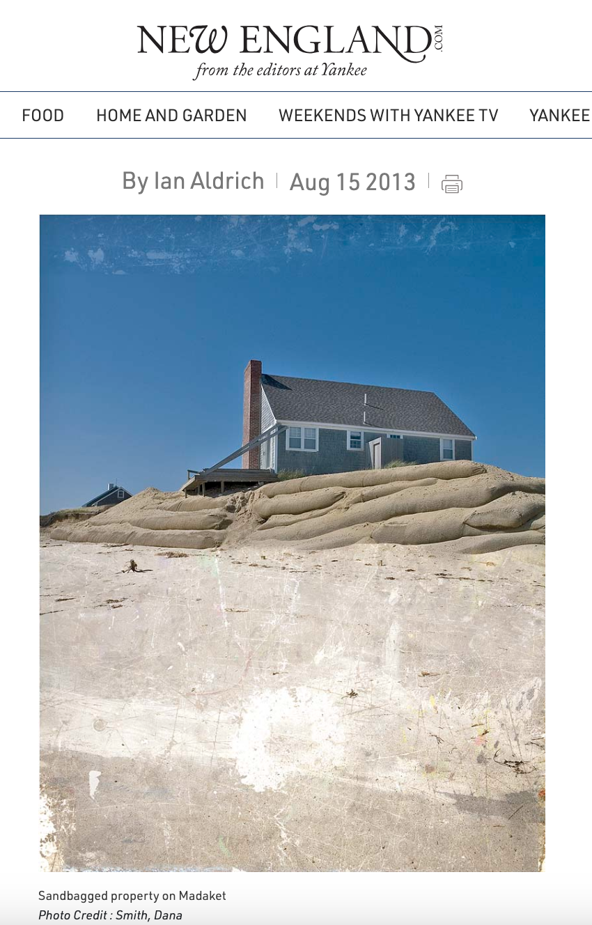
Today, his home survives defiantly in an area where the erosion rate currently averages 12 feet a year, the highest rate in Massachusetts and maybe in the Northeast. The evidence of that is everywhere: in nearby lots whose homes have been moved or lost to the sea, in the abandoned section of road that continues on past Ratner’s property before disappearing into the sand, in a forgotten concrete sewage tank that sits smack in the middle of the beach. Ratner estimates he’s sunk $500,000 into saving his home, armoring the front and sides with enormous geotextile bags filled with sand — hundreds of them, weighing many tons apiece, forming a wall that runs 45 feet deep, 20 feet of which is visible above the water surface, dividing building from ocean.
…. Still the ocean comes. Maybe 20 feet separates the building’s foundation from the outer edge of the bags. Temporary walls of plywood and pressure-treated posts protect the driveway and plants from sand drift. Ratner’s place looks more like a fortress than a dam.
When he first noticed he was losing land, in the early 1990s, he wasn’t alarmed; 100 feet of grass, 30 feet of dune, and another 30 feet of beach separated his house from the sea. But shifting shoals and storms gnawed away at all that protection. Having already lost a deck to the surging ocean, Ratner began dropping the first set of bags in front of his house in 1995. “My wife used to complain that we couldn’t see the water from our first-floor bedroom,” Ratner says. ” ‘Why did you build the house so far back?’ she’d ask me. Well, it’s a good thing we did, or we’d have lost it by now.”
It’s an old story. Land and homes have been lost to the sea for generations on Nantucket, a 48-square-mile patch of sandy earth, deposited by a glacier, that became an island when the ice melted and the seas rose around it more than 10,000 years ago. It’s why native islanders have often shied away from the coast when building their homes, or placed them on movable skids if they built near the sea. “Erosion is just something we live with,” says one islander. “You gotta realize that sooner or later the water is going to come visiting.”
But that’s not something that Ratner and other wealthy summer residents who have scooped up valuable, but vulnerable, waterfront property over the years are prepared to concede. That battle with nature — a confidence in the belief that determination, technology, and money can restrain the elements — is an old story, too. As is the outcome. In recent years, millions of dollars on this island have washed out to sea.
…. Weymar’s house been lucky: It still sits on its original 1916 foundation. But nobody has to remind him of what he’s up against. Along with the scientists he’s hired, he’s made a careful study of the water and the land, familiarized himself with practically every erosion-fighting method available, and founded the Siasconset Beach Preservation Fund (SBPF), a nonprofit with more than 400 contributors, dedicated to addressing the community’s erosion issues.
Today ‘Sconset Beach is a reminder of lost battles. The mechanically doomed pumps and valve stems from a huge dewatering system that was supposed to lower the beach’s water table, and remnants of temporary terracing projects whose bags and posts storms have tossed about like little toys — they’re all in plain sight, $15 million in research and labor to fight the inevitable.
Even here on Nantucket that’s a lot of money. “It’s just stubbornness and arrogance on their part, because they have money, so they think they can outsmart Mother Nature,” says one ‘Sconset native. “That’s the risk you take. I wouldn’t have bought property on an eroding bluff, but that’s just common sense to me.”